
Guidelines for submitting articles to San Javier Today
Hello, and thank you for choosing sanjavier.today to publicise your organisation’s info or event.
San Javier Today is a website set up by Murcia Today specifically for residents of the urbanisation in Southwest Murcia, providing news and information on what’s happening in the local area, which is the largest English-speaking expat area in the Region of Murcia.
When submitting text to be included on San Javier Today, please abide by the following guidelines so we can upload your article as swiftly as possible:
Send an email to editor@spaintodayonline.com or contact@murciatoday.com
Attach the information in a Word Document or Google Doc
Include all relevant points, including:
Who is the organisation running the event?
Where is it happening?
When?
How much does it cost?
Is it necessary to book beforehand, or can people just show up on the day?
…but try not to exceed 300 words
Also attach a photo to illustrate your article, no more than 100kb

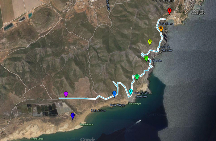
4-kilometre geological walk from Cala Reona to Salinas del Rasall in Calblanque regional park
This pleasant walk in Calblanque is of great interest to geologists
 Distance: 4km, one way
Start point: Cala Reona
Difficulty level: medium
This 4-kilometre route, which begins in Cala Reona and ends at the Salinas del Rasall in the regional park of Calblanque, both within the municipality of Cartagena, is described as being of medium difficulty and includes the following points of geological interest:
1. Cala Reona: The main feature here is the karst formation in the eolianite rocks, which are sandstone cemented by the dissolving of calcium carbonate. Erosion has created sharp crests and dips, which are known as a limestone pavement, and the area is sometimes known as the Punta de los Saleros on account of the salt which accumulates in the dips.
2. Punta Loba: here there is a large open mine which has been fenced off to avoid accidents, and in rough conditions the sea splashes up through the cavity.
3. Cerro del Atalayón: this mountain contains the “Filón Poderoso”, which was rich in silver, iron and lead. In the tips on the lower slopes are hematites, siderite and goethite.
4. Punta Barriga: the impressive graphite cliffs show inclines and fractures caused by tectonic movement.
5. Cala de los Déntoles: there is a sharp contrast here between the dark colours of the schists and the white eolianites, where erosion has formed shelters which were used in prehistoric times by early humans collecting molluscs.
6. Mirador de Punta Negra: the landscape here is the result of the bay which was formed by the advancing coastline. Later, when the sea level dropped, sandy sediment emerged and formed dunes, which are now fossilized.
7. Cala Magre: the reddish sediments here are rich in iron oxide, and the name of the cove probably derives from the Arabic “almagre”, which is used to refer to red clay.
8. Punta Blanca: at Punta Blanca two types of dune can be observed. One is the shifting dunes consisting of loose sand, and the other is the fossil dunes through which the seawater now splashes. The name of Calblanque comes from the white colour of the latter, which have been named as a geo-morphological reserve within the regional park of Calblanque.
9. Salinas del Rasall: the salt flats of Rasall were two natural lagoons into which rainwater flowed from the small flood channels, and were used for salt extraction in the 20th century until the 1990s. They were recovered in 2008 for their environmental and ecological value.
Note: caution is required on the stretch between Punta Espada and Punta Barriga, and walkers are advised to keep away from the subsidence in Punta Loba. Exposure to hot sun and strong winds should be avoided.
Click for information regarding the Visitor Centre of Los Cobaticas in the Calblanque regional park, Cartagena.
The natural park of Calblanque is in the east of the municipality of Cartagena. Click Cartagena for more information about Cartagena, its history, restaurants and all the different places to visit and things to do within the municipality.
This park also lies within the area broadly classified as the Mar Menor. Click Mar Menor to go to the Mar Menor section which gathers places to visit, restaurants, things to do, what’s on and local news,
Click for map, Cala Reona-Salinas del Rasall Walk.


